California wildfire smoke dimmed solarenergy in 2020 IOPenvironment
1. IntroductionWildfires are some of the most powerful natural disasters on Earth, often leading to devastating effects. There is no doubt that wildland fire activity in the United States has intensified over recent decades [7, 19, 40, 58], and is projected to increase in forthcoming years [3, 60, 63]. These changes are especially concerning for the U.S. wildland-urban interface, which has burgeoned to the tune of approximately 350 000 homes per year over the last two decades [10].
Here, we ask the critical question: during a large-scale wildfire event, what is the quantitative impact of smoke emissions on solar energy forecasting? To address this fundamental question, we undertake a multifaceted approach that fuses both national scale observational networks and an NWP model. We will demonstrate the smoke effects during extreme wildfire conditions that plagued the Western U.S. in 2020.
2.2. WRF model configurationTo complement the observations, we use the WRF model [48]. Our developments are part of the WRF-Solar version 2 modeling framework, which builds on the widely-used WRF-Solar version 1 modeling package [29]. The WRF model setup used for the simulations presented herein follow the WRF-Solar reference configuration . Notable deviations from the reference configuration include a two-domain structure, with the outer domain using a horizontal grid spacing, km ).
2.3. California Independent System Operator dataWe utilize freely available reports from the CAISO to link the smoke plumes to solar energy losses. The CAISO variables used in this study, Real-Time Dispatch and Hour-Ahead Scheduling Process , are reported at 5 and 60 min intervals, respectively. The RTD represents the amount of solar power produced by each site and available for release prior to any potential curtailments.
Forward trajectories from HYSPLIT, launched at different locations where wildfires actively burned between 11 September and 15 September, illustrate clearly the smoke transport from the Western U.S. across the country into the Northeastern U.S. ). Particulate matter measurements from ground stations stations in the Western U.S. registered extended exceedances during the 9 d period ), leading to extreme exposures over Oregon and Washington ) for several vulnerable populations .
During energy utility operations, CAISO utilizes renewable forecast information in multiple real-time market updates throughout the day. The two real-time market updates highlighted in this article are the HASP and RTD. Examining the difference between the RTD and HASP, with a negative value indicating less-than-expected solar power production, provides insight into the solar power forecast error ).
There remain many uncertainties and challenges that should be addressed for more accurate solar forecasting as it pertains to smoke. For example, while the overall bias in AOD seems small in figure 1, there is still a lot of scatter, which suggests large short-term biases in AOD and thus solar energy production. We hypothesize that a major contributing factor pertains to predicting future fire behavior .
Brasil Últimas Notícias, Brasil Manchetes
Similar News:Você também pode ler notícias semelhantes a esta que coletamos de outras fontes de notícias.
 Alabama coal plant still the largest greenhouse gas emitter in United StatesFor the seventh consecutive year, the largest source of planet-warming greenhouse gases in the United States is a coal-fired power plant in Alabama. 🏭 Read about it:
Consulte Mais informação »
 How a dangerous stew of air pollution is choking the United StatesFires and droughts in the western states are getting worse — and they’re combining with industrial sources to threaten air quality and people’s health.
Consulte Mais informação »
Pre-agricultural soil erosion rates in the midwestern United States | Geology | GeoScienceWorld
Consulte Mais informação »
 Gold Price Forecast: XAU/USD eyes further upside on downbeat United States Treasury bond yieldsGold Price Forecast: XAU/USD eyes further upside on downbeat United States Treasury bond yields – by anilpanchal7 Gold XAUUSD YieldCurve SEO Bonds
Consulte Mais informação »
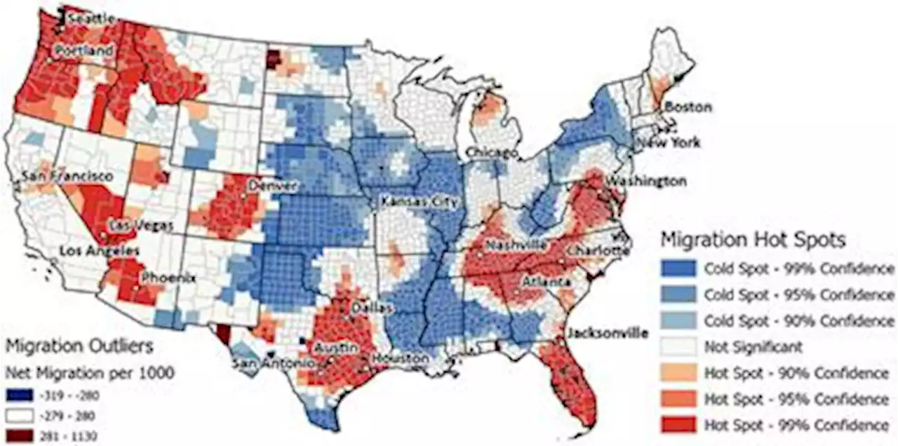 Frontiers | Flocking to fire: How climate and natural hazards shape human migration across the United StatesAs global climate change progresses, the United States (US) is expected to experience warmer temperatures as well as more frequent and severe extreme weather events, including heat waves, hurricanes, and wildfires. Each year, these events cost dozens of lives and do billions of dollars’ worth of damage, but there has been limited research on how they influence human decisions about migration. Are people moving towards or away from areas most at risk from these climate threats? Here, we examine recent (2010 to 2020) trends in human migration across the US in relation to features of the natural landscape and climate, as well as frequencies of various natural hazards. Controlling for socioeconomic and environmental factors, we found that people have moved away from areas most affected by heat waves and hurricanes, but towards areas most affected by wildfires. This relationship may suggest that, for many, the dangers of wildfires do not yet outweigh the perceived benefits of life in fire-prone areas. We also found that people have been moving towards metropolitan areas with relatively hot summers, a dangerous public health trend if mean and maximum temperatures continue to rise, as projected in most climate scenarios. These results have implications for policymakers and planners as they prepare strategies to mitigate climate change and natural hazards in areas attracting migrants.
Consulte Mais informação »