
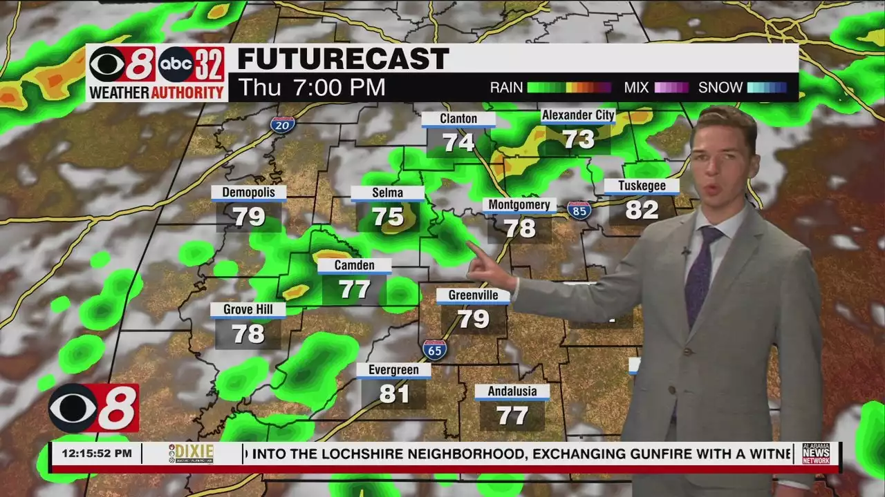
A few storms may become severe through early Thursday evening, capable of wind gusts up to 60 mph. The storm prediction center places a marginal (level 1/5) risk across the northwest half or so of Alabama.
Early Thursday morning was quite sunny across central and south Alabama. However, clouds increased through midday, with most locations partly cloudy by then. A handful of isolated showers formed among the clouds, mainly east of I-65 and north of I-85. Shower and storm coverage increases Thursday, especially during the late afternoon and early evening. Rain coverage Thursday certainly looks higher than recent days.
A few storms may become severe through the early evening, capable of wind gusts up to 60 mph. The storm prediction center places a marginal risk across the northwest half or so of Alabama. That includes some of our northwestern communities. The enhanced shower and storm coverage results from an approaching cold front. The front likely pushes through our area overnight. However, it looks like most of the rain ends overnight.
Temperatures peak in the low to perhaps mid 90s for some Thursday afternoon. Thursday night lows range from the upper 60s to low 70s. Isolated to widely scattered showers or storms form by Friday afternoon. The storm prediction center also indicates a few of those storms may become strong. A marginal risk area includes far south Alabama Friday. The strongest storms could produce wind gusts up to 60 mph.
With the “cold” front located to our south Friday, temperatures remain slightly lower. However, some locations still approach 90° during the afternoon. Rain winds down Friday evening, and the sky becomes clear Friday night. Low temperatures fall into the mid 60s. The weekend begins mainly sunny and likely rain-free Saturday. Afternoon temperatures peak in the low 90s. Isolated showers or storms appear possible Sunday, with highs in the low 90s.
The rain chance could be a bit higher next Monday than Sunday. However, the rain chance falls Tuesday, and especially Wednesday. Meanwhile, temperatures remain hot, and trend even hotter around the middle of next week. Afternoon highs trend from the low 90s Monday and Tuesday into the mid 90s next Wednesday. The rain chance may slightly increase again late next week, curbing the heat somewhat.
Brasil Últimas Notícias, Brasil Manchetes
Similar News:Você também pode ler notícias semelhantes a esta que coletamos de outras fontes de notícias.
 D.C.-area forecast: High heat again today, scattered storms late ThursdayAfter another hot one today, scattered storms tomorrow afternoon into evening could be strong to severe.
Consulte Mais informação »
 D.C.-area forecast: Strong storms late today bring heat relief by FridayHeavy downpours, frequent lightning and strong wind gusts are probable.
Consulte Mais informação »
 June Starts Hot, But Rain Chances Rise Late This Week - Alabama NewsWednesday afternoon looks hot and partly cloudy, with only a handful of brief showers or storms. Temperatures peak in the low 90s.
Consulte Mais informação »
 Heat, Isolated Showers/Storms Close May, Open June - Alabama NewsTemperatures around sunrise were in the 60s in many locations. However, afternoon temperatures rise to near or above 90° just about everywhere.
Consulte Mais informação »
 Mama June secretly marries boyfriend Justin StroudThe “From Not to Hot” star and her beau secretly married at a courthouse in Georgia in March after less than one year of dating, according to a new report.
Consulte Mais informação »